Designed to withstand mud, water, dirt, ice, and practically anything you throw at it — the Mudmaster is one of Casio’s most rugged G-Shock wristwatches.
This month we tested a pair of Casio’s latest and most advanced analog-digital solar quartz-powered navigational wrist computers: the Mudmaster GWG2000-1A1 and GWG2000-1A3. Similar to Casio’s lower-priced and less durable ProTrek, Mudmasters utilize multiple sensors to calculate altitude, temperature/barometric pressure, and compass bearing. Most notably, the Mudmaster case and construction are more premium — including the use of a generous amount of forged carbon and stainless steel, a sapphire crystal, a higher shock rating, and perhaps most interestingly, there’s no connection to a smartphone as there is with the ProTrek. With no smartphone connection, the Mudmaster certainly offers a more purist experience.

Beyond the ultra-accurate timekeeping — calibrated via multi-band radio signals (not via Bluetooth) — the digital altimeter and analog-digital compass are two of the Mudmaster’s marquee features. Accordingly, the altimeter and compass can be accessed via dedicated buttons on the right side of the case. In addition, the Mudmaster has a barometer/thermometer, full auto-calendar, a countdown timer, stopwatch, 5 alarms — all accessed using the button located on the lower left side of the case — along with the arrow-shaped indicator located between 9 and 10 on the dial, which confirms the current multi-function mode. The analog arrow is more than likely there for the visual appeal, considering that the digital display also shows the current mode, and is where the actual information such as the altitude, barometric pressure, and temperature readout.

To begin this two-location field report, I visited Denver’s most famous mile marker, located at the steps that lead up to the entrance of the Colorado State Capital. There are also mile-high markers on the other stair sets that surround the building, but it’s the stairs that face West (towards the Rocky mountains) where the historic marker is located. And when I say historic marker, this refers to the words “ONE MILE ABOVE SEA LEVEL” that was carved in the Colorado-sourced granite on the 15th stair riser (starting from the bottom) in 1947. Prior to that, several plaques had been stolen, including the first marker dating back to 1909. While the 15th stair is where many visitors gravitate towards when taking photos, the altitude was recalculated by Colorado State University engineering students in 1969, and it was determined at that time that it was actually the 18th stair that represented one mile high, or 5,280 feet, so a circular brass benchmark was embedded in that step. In 2003, another measurement was taken and it was then determined that it was actually the 13th step that represented 5,280 feet above sea level, and at the time, that stair riser was embedded with a circular brass medallion, like the 18th step. As of 2022, the 13th step is still recognized as the official 5,280 feet above sea level step.

With a Mudmaster in hand, I switched to altimeter mode, which displays the altitude in the small digital screen on the lower portion of the dial, and the reading at the 13th step read 5,285 feet, or off by 5 ft which may seem like a significant variance, however considering that altitude is calculated using barometric pressure, which is constantly changing, this is about as close as you can expect to get without calibrating it locally first (plus the altimeter works in increments of 5 feet, when in imperial mode). To then get the pure 5,280 feet readout you see above, I simply unscrewed and pulled out the crown (switching into “Offset” mode), and turned the crown one turn, until the display read 5,280 feet, meaning it was now calibrated correctly to this location.

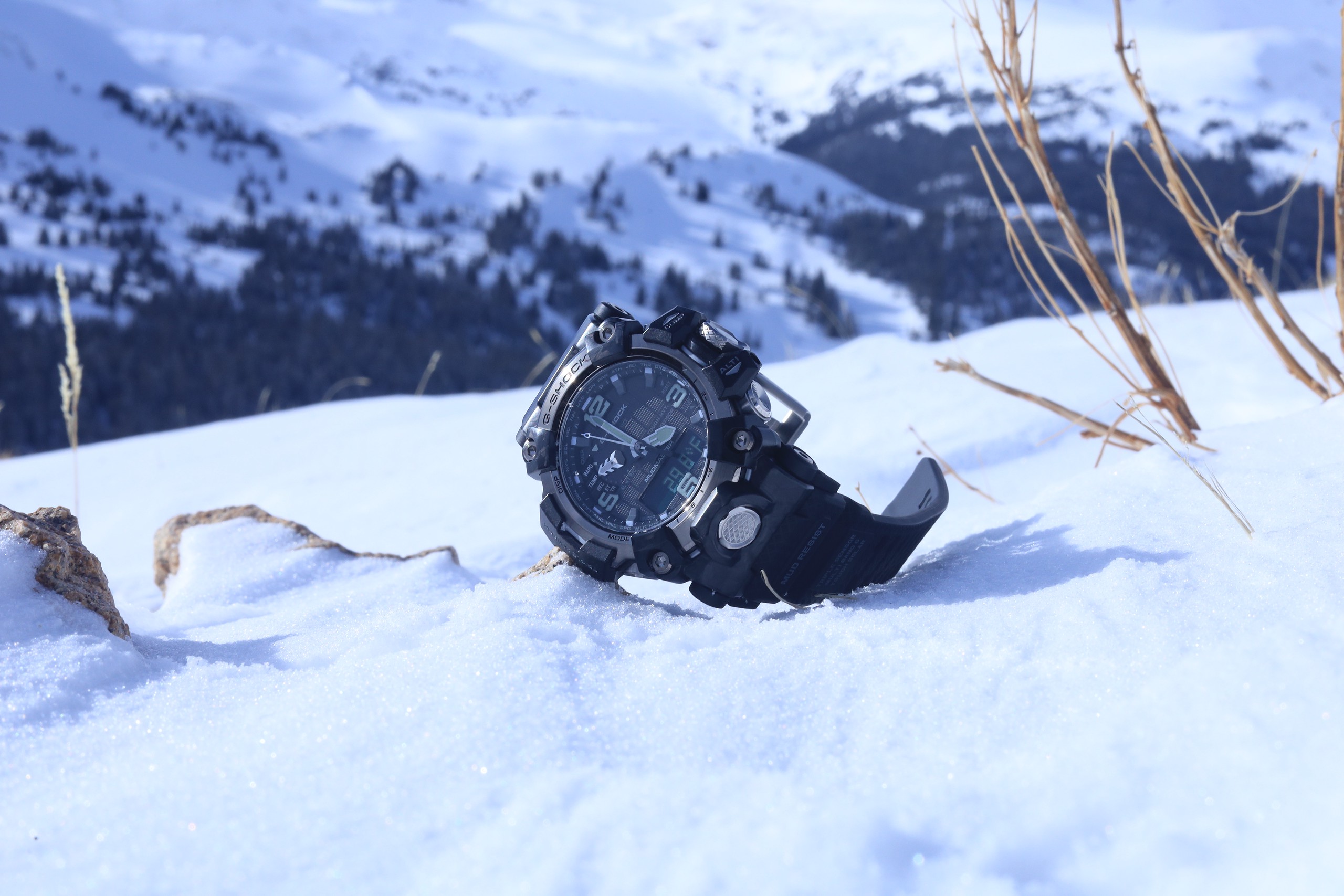
After the local altitude test was done, it was time to head to one of my favorite Rocky Mountains destinations: Loveland Pass. To the northwest of the pass is Loveland Ski Area, and to the south/southeast side is Arapahoe Basin Ski Area (which is partially visible in some of the photos). The pass itself is also a popular destination for those looking to hike, take photos at the Loveland Pass sign, or even for those wanting to ski or snowboard in the backcountry (there was an unexpected avalanche there this month, although it’s not as dangerous as some other backcountry areas). Loveland Pass is also where the Continental Divide passes through Colorado (also called the Western Divide, it’s a hydrological divide that separates rivers that drain into the Pacific and those that drain into the Atlantic in North America). Knowing the ephemeral nature of the often snowy pass — the highest in Colorado that stays open regularly during the snowy season, although the pass does close occasionally when there’s a blizzard — I planned for (and hoped for) a mixture of the sun as well as snow. Not surprisingly, mother nature delivered.


Upon arrival, I went to the 11,990 Loveland Pass elevation sign, reset the altimeter to factory settings, and made a small manual calibration adjustment in “offset” mode, as I had done at the Colorado State Capital building. From there, the Mudmaster was locked in and calibrated at the altitude listed the altitude marker sign (reference altitude), which is exactly what G-Shock suggests you do before climbing, hiking, or whatever you intend to do will require an altimeter.

G-Shock’s operation manual explicitly states: “Do not use this watch while skydiving, hang gliding, paragliding, gyrocopter flying, glider flying, or engaged in other activities where altitude changes suddenly. Altitude readings produced by this watch are not intended for special-purpose or industrial level use. In an aircraft, the watch measures the in-cabin pressurized air pressure, so readings will not match altitudes announced by the crew. This watch uses International Standard Atmosphere (ISA) relative altitude data defined by the International Civil Aviation Organization (ICAO). Barometric pressure generally becomes lower as altitude increases. Correct measurement may not be possible under the conditions: During unstable atmospheric conditions, during sudden temperature changes, after the watch has been subjected to strong impact.”


Verdict
Mudmasters are large, mostly because they are an instrument, which can precisely calculate temperate, barometric pressure, altitude, and compass bearing. The ProTrek can do all these things too, plus connect to a smartphone for advanced features and logging. However, there’s something about not connecting or relying on a smartphone. For instance, what happens if the smartphone runs out of batteries or shuts down, which mine did while hiking at Loveland Pass. When the temperature plummeted my iPhone XS shut off completely, either due to the low battery or the temperature being too low. The Mudmaster kept working. However, when I checked the temperature, I saw it drop from roughly 28 degrees, then quickly to 18 degrees, then it stopped registering at all, which is because the Mudmaster can only calculate temperature down to 14 degrees Fahrenheit before showing an error screen, and as I lost feeling on the fingertips in my left hand, I knew the temperature had dropped below that threshold. (The Mudmaster also has a barometric pressure alarm which would have likely gone off had I been operating in that mode, warning me of the extreme cold.) What was good about seeing the temperature go so low on the screen, is that it was effectively a warning to me I should leave, which I did, immediately.

Even though the Mudmaster is large, measuring over 54 mm across with the crown guards included, it still worked well on my 7″ wrist, comfort-wise, and I thought it was attractive to look at with a tee shirt or with a coat and gloves (as pictured). For this sports-orient type of watch, the oversized look is both appropriate visually and the size befits operating with gloves on, as I was doing.

The sapphire glass and polished gray PVD bezel flange, combined with the marbled aesthetic of the forged carbon parts look premium and this is clearly the most upscale Mudmaster yet. Thanks to that forged carbon, and the carbon core guard structure, the watch, which also uses resin and stainless steel, weighs in at a moderate 106 grams — which is really light relative to the dimensions and made for a more comfortable experience on the wrist than I expected.

On one hand, the easy access buttons of the altimeter, my favorite feature of the watch, makes operating the Mudmaster quite simplistic, which is a positive. However, on the other hand, this watch has a 37-page operating manual — which I assume engineering types will love — and others might not care to look at. Overall, I found the instructions easy to follow, although you need to study ahead of time, or risk not knowing it once out in the field.

G-Shock has upgraded the Mudmaster in about every way possible, from improved aesthetics to lightness and ergonomics and operation. I wish functions like the altimeter required less manual input or that the temperature reading did not need to take multiple calculations before the temperature shown is accurate, yet ultimately the measurements seemed reliable enough if the instruments were used properly, meaning calibration of the altimeter, or waiting for the temperature to take multiple calculations to get the accurate temperature.

Everything works without a lot of fuss and that watch has a chunky look that many will want in a watch like this. In spite of the rather high $800 price point, you are getting quite a fun instrument (or toy) along with a watch. Even without Bluetooth timekeeping, Multi-Band 6 Atomic calibration is dead accurate down to the second (as you can see in the shot below). All I had to do when I got the watch, was set the time zone to Denver once, using the city bezel, and then you can just focus purely on using the tools as instruments, as intended.

Learn more at G-Shock.
SPECIFICATIONS:
G-Shock Mudmaster
Reference: GWG2000-1A1 – black, GWG2000-1A3 – green
Year: 2022
Total Weight: 160 grams (on resin strap)
Case Diameter: 50 mm not including crown guard (54 mm with crown guards)
Case Thickness: 16.5 mm
Lug-to-Lug: 61.5 mm
Bezel diameter: 44 mm – 46 mm
Lug Width: 25.5 mm / 21.5 mm
Crown Diameter: 11 mm
Glass: Flat sapphire, sits below the plane of the bezel (armored)
Depth Rating: 200 meters
References:
https://www.5280.com/2015/05/only-in-colorado-the-capitols-mile-high-steps
https://www.atlasobscura.com/places/mile-high-steps-at-the-colorado-state-capitol
https://en.wikipedia.org/wiki/Loveland_Pass
https://en.wikipedia.org/wiki/Continental_Divide_of_the_Americas


